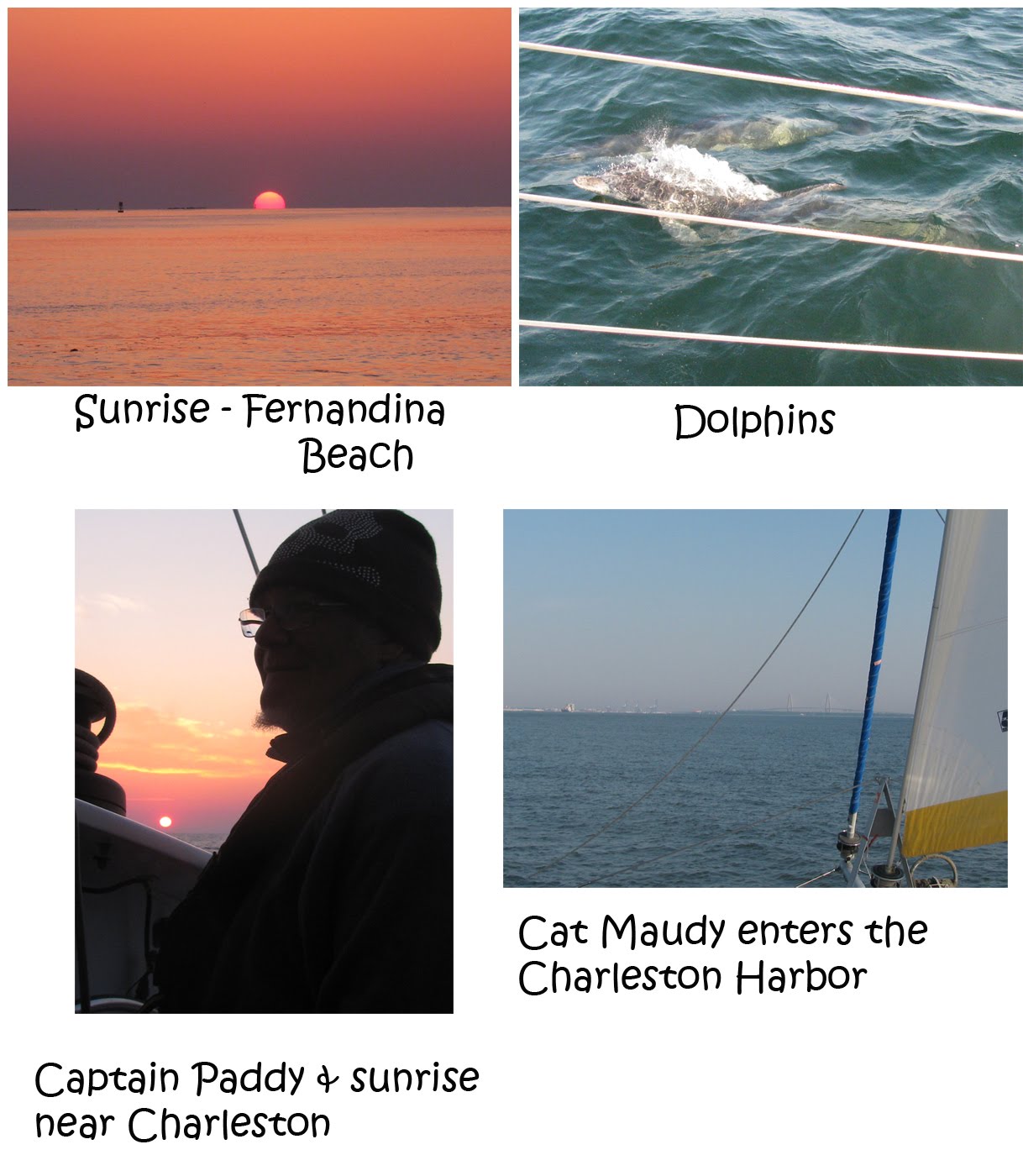
We depart our mooring in Fernandina Beach with a swift moving ebbing current. Cat Maudy is nearly a go-fast boat moving at 10 knots leaving the harbor. With now 2 days of barely any winds – the seas are smooth, and we head northward to our next day hop destination — St. Catherine’s Sound – just south of Savannah Georgia.
Twenty miles north of Fernandina, we approached the channel to St Simon’s Inlet. A large motor yacht is hailing the Coast Guard requesting guidance into the channel. The Coast Guard refuses to help. Not even a little – like hey — head “west” or something like that. We could see the motor yacht just ahead of us. The Captain gave up asking the Coasties for help…and hailed us to see if we could give any assistance. Paddy told him to head at 303 degrees from the outer sea buoy…and follow the channel buoys ‘red…right…returning’. The other captain profusely thanked us for our help. He ‘splained he had been offshore and up for 35 hours, was shorthanded on crew…and probably too tired to see the difference between land and water. While I have to wonder why a boat like his doesn’t have GPS software that will show him the way, or even a good set of binoculars to SEE the channel markers….I can appreciate being overly tired on your boat.
Can we talk? Has the Coast Guard stopped helping the little people on boats – i.e. fishermen and cruisers? Do they not like us? Maybe the Great Recession has hit them hard – and they don’t have any more money for boat fuel? Whatever it is, the Coasties seem preoccupied with other important duties. Such as polishing their guns, training to shoot at boats, or practicing war games on coastal waterways. These are skills your average cruising mariner can appreciate. During one stretch, for 15 hours…the Coast Guard repeatedly reported a disabled vessel 15 miles off shore that was taking on water — and all OTHER vessels should assist. Now, if I was on a boat that was sinking…it sure would have been nice if help could arrive. OK? Just say’n.
The landscape of Georgia is a stark contrast – from South Florida. South Florida is filled with high rise hotels and condos – with every inch of beachfront property owned by wealthy individuals or corporations. In Georgia – there are no buildings….no (or very little) beachfront development. It is quite refreshing. The coastline consists of one island after another, separated by “sounds”. Most of the sounds provide access from the ocean — to inland, if you are planning to use a rowboat. The sounds are extremely shallow, and include shoaling out 6-8 miles into the ocean. There are TWO deep water channels in Georgia. One in the southern end called St Simon’s Inlet – which takes you into Brunswick, and the other further north leads you into Savannah. In between, unless you REALLY REALLY want to get to Georgia from the ocean, and are willing to risk running aground….you might just want to keep on going.
This is exactly what we discovered. After motor-sailing from 6:30AM to 4PM – we were two miles away from the channel into St Catherine’s Sound. But, when we got to the “channel markers” – we discovered there were none. Apparently someone decided that the channel into St Catherine’s Sound….starts 3 miles IN from the outer shoal. This means, we would have had to “wing it” for a few miles HOPING we don’t run aground…til we made it to the “channel”. Think of it this way – you are in your car, and trying to get to I-95….but there is a big forest for 3 miles between you and the highway. You have to go off-roadin. You have no idea how to get TO I-95…but you have to go thru the forest to get there. So, if you can figure it out….and weave thru the trees, then you get to hop on the highway. Otherwise, enjoy the trees in the forest.
So, here we are – 4PM at St. Catherine’s Sound. We couldn’t safely get into shore. It is time to consider some new options. Our next port is Savannah Georgia. The outer sea buoy is located 20 miles from us. We could motor there at 7knots….but it is a long channel from the sea buoy to land – at least 8 miles. From there we would need to travel another 12 miles up the river to find any anchorage. It would be dark by 8pm. Not a good option.
The only other option – is to keep going. All night, to Charleston. It’s hard to imagine that this is our best option, especially after I had just sworn off of any more overnight sails and peanut butter and jelly sandwiches. But, it is our best option. Really, our only option. In addition, the course correction needed to head to Charleston — allows us to shut off the motors, and just sail. This puts Paddy in a VERY good mood. The weather is favorable – 8 knot winds from the south…and Cat Maudy is back to being a sailing machine. She loves lite air – and is cruising along at 6 knots. Nice.
The sail is quickly becoming the best sail of our trip. With a gentle breeze, and flat seas…Cat Maudy is eating up the light air off her stern quarter. We predicted arrival into the Charleston Harbor around 8AM. I rush to the galley – and prepare dinner and snacks for the night. PB&J’s all around.
Just shy of the Tybee Sound off the coast of Georgia, we are greeted by a school of dolphins. These creatures love to swim, jump and play near the beam and bow of our boat. Their presence makes for a wonderful diversion from staring at the horizon, the trip odometer or the most current GPS position. I grab my camera to capture the moment – and Flipper & Friends do their best to avoid being filmed. Switching to video mode proved to have better results. Gotcha!
We reached the channel marker for Savannah while we still had some daylight. This is a good thing. Savannah is an active shipping port – and despite the fact that we only had a mile to go to REACH the channel…incoming and outgoing commercial freighters were moving in and out of the channel at 15 and 23 knots. We had to GIBE the boat twice to let the freighters have right of way, before Cat Maudy could sprint to get to the other side of the channel.
By 8:30PM, the twilight from the setting sun disappeared, and a three quarter moon rises to provide just enough glow for low lite, nite time visibility. The sky is clear, and with the combination of starlight and moonlight, gentle lapping seas, and a constant southwest breeze – the night was becoming magical. Still, this is no time to let down your guard. We are between 8 and 10 miles offshore, and there are unmarked buoys, sunken ships and depths as shallow as 20 feet. Every 5 minutes we scan the dark horizon for any shadows or lights, the charts for any course deviations, the AIS software in case a big ship is heading our way, and the radar to show us anything else we may have missed. The attention to detail feels much greater at nighttime.
VHF channel 16 is buzzing with activity. Flares go off near St. Catherine’s Sound – indicating some mariner is in trouble. A fishing vessel 60 miles offshore has a disabled engine. More vessels hail the Coasties with their troubles….and true to form, the Coasties simply broadcast the troubled position – and suggest other boaters in your area assist you. We notice the lights of two other sailboats who appear to be traveling a similar course to ours, en route to Charleston. Our comfort factor goes up a notch. We have “ghost friends” nearby.
By 1AM, the winds had shifted to the southwest, and had lightened up. Our speeds were degrading to the “TOO SLOW” range. Time to turn one engine back on and kick up the speed. We continued with one engine, motor sailing until daybreak (6AM). The shipping channel into Charleston is now less than 11 miles away. We make a slight course change toward the channel – and this gives us a better direction for the winds. Back to sailing – and Cat Maudy trucks along at 7 knots!
Just as we arrive near the Charleston shipping channel – the Coast Guard announces they will be shooting off their guns at 8AM near Charleston. Of course! They want all mariners to stay away from the shooting zone. At the same time, they announce a vessel is taking on water and needs help. Perhaps another boater could help them? hmmmm….. We sail as quickly as possible into the Charleston Harbor…away from the shooting spree. Our two “unknown” sailboat friends from the night, arrive shortly thereafter.
While sailing up the harbor, and back in cell phone range, I hook up a game of tennis – with my Charleston “tennis connection”, Cindy. The overnight sail is over, and it’s time to focus on getting endorphins. Cindy informs us that this weekend will be buzzing with the “Blessing of the Shrimp Fleet” – a big event that occurs on Sunday here in Charleston / Mt. Pleasant. It appears to be an opportunity to eat a LOT of shrimp. We vow to find out more about this – once we get some much needed sleep.
We grab a slip at the Charleston City Marina. The folks here at the City Marina are the nicest imaginable. They speak with a delightful southern drawl. My conversation with the dock hand goes like this:
me: How was the weather this winter in Charleston?
CityMarina folks (CMF): yes, ma’am…we sur had a col one
me: Did you have any snow?
CMF: yes ma’am…we even made sno balls
me: OK, I’m going to throw you this bow line…are you ready
CMF: yes ma’am….thank you ma’am
me: OK, I’m gonna throw you this spring line….ready?
CMF: yes ma’am…thank you ma’am
…and on and on
I then ask the dock hand if he knows anything about the “Blessing of the Shrimp Fleet”. Most people would say – “no sorry..” and be done with it. But, not here. We are in the heart of southern hospitality – Charleston. The dock hand replies “yes ma’am….I’ve heard of it…let me find out more for you”….and contacts the Marina office to get more information for me. The lady at the marina office, takes it on her own to research the “Blessing of the Shrimp Fleet”, and then comes to FIND ME (walking down the pier) – and tell me how they can help me to GET THERE. Not just with a map….but they will DRIVE US to the other side of the peninsula, and then pick us up to bring us back….and wanted to know WHEN we wanted to go. OMG. How hospitable is that??
